Geophysical Equipment Pool
The Bristol Geophysics group owns and manages a pool of equipment for experiments and surveys at a range of scales and a broad variety of problems. This equipment supports both research and teaching activities in the group. If you need any further information, or wish to use any of the equipment, please contact the Geophysics Laboratory & Field Manager, Dr Antony Butcher
Gravity Surveying
We operate four state of the art gravimeters:
These are used in shallow profile surveys, as well as longer term occupations for studying time variant processes.
Broadband Seismic
Lithospheric scale research in the Geophysics group is supported by our array of broadband seismometers. We currently operate:
- 6 Nanometrics Trillium 120P
- 4 Guralp Certimus
- 4 Guralp 6TD
- 3 Guralp 3ESPC
- 2 Guralp 3T-120
- 2 Guralp Fortis force-balance accelerometers with Guralp Minimus digitizers
These can be used in conjunction with instruments on temporary loan from the national equipment pool, SEIS-UK.
Shallow and Environmental Geophysical Surveying
We operate a number of instruments for shallow surveying, primarily for teaching purposes. These include:
- Two 24-channel Geometrics Geode seismograph
- 4.5 and 10 Hz geophones
- TopCon GPT7505 EDSM
- 2 each EM31-MK2
- EM61
- Sensors & Software Pulse EKKO1000
- Mala GPR system with XV11 monitor
- ABEM Terrameter resistivity/IP system
- IRIS Syscal junior ERT system
- GEM GSM-19T proton precession magnetometer
- Geometrics G816 magnetometer
- Heliflux magnetic locator
- Pico seismometer array
In addition, we collaborate with several exploration consultancies (such as TerraDat) which provide experience with other techniques.
GPS surveying
The satellite-based global positioning system has revolutionised the whole field of Earth observation. Accuracy on the scale of meters is now easily achievable in exploration scale surveys, and on the scale of millimetres when longer term observatories are used. Members of the group use both of these modes for a variety of problems. We have state of the art GPS systems:
- 2 Leica SR20 GPS system
- 2 TOPCON HyperPro units
- 6 Leica GR30 GNSS reference server and 6 x AS10 Antennae (9 additional stations semi-permanently deployed in Ethiopia).
These methods often provide invaluable geographic information (such as terrain corrections) for other geophysical techniques.
Infrasound
- 2 each Hyperion IFS-3114 Infrasound sensor
- Chaparral 25Vx infrasound sensor
Drone
- DJI Phantom 3 Series Standard - Quadcopter
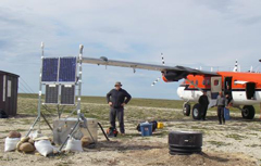
Remote broadband seismic station deployment in Northern Canada
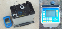
Gravity meters
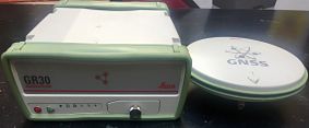
Leica GR30
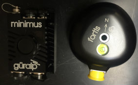
Guralp Fortis force-balance accelerometers